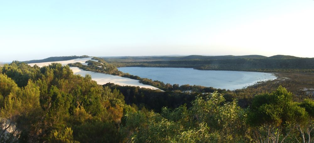
I leave the hostel and hitch hike towards Inskip point. One hour later I am on the barge that drops all vehicles and I on the top South of Fraser island. Carrying 20 kg, I start walking North on a closed 4WD track towards Dili Village. I am astonished by the easiness of the walk on compact sand covered with decomposing vegetation. As usual, walking alone lets me see many animals like goannas over 80cm long. At Dili Village I follow the Great Walk and reach Lake Boomanjin as planned just before sunset. The next morning, I watch the sun rising in the mirror of the lake. A color scene I enjoy wit my camera.
Once the Great Walk is finished, I only have to follow the sand highway going north. I pass 4WDs, buses and even planes. Some drivers are quiet curious and slow down to my side to propose me a lift further. I kindly refuse any lift! I make a small wave with my finger to each vehicle passing me. Every Australian sent this back to me. This is a sign Australians answer with pleasure. This way of greeting is often used in the country where people are isolated.
Indian head is the only rock formation on the island. It's where one can have a nice lookout over the junction between 2 colors of the ocean. The view from the top is incredible. There I take my longest break in order to spot whales, dolphins, sharks, turtles and rays. I am staring at the ocean when suddenly a completely unexpected event happens: a manta ray goes into a wave to take a jump out of the water. The entire body flew over the water for less than a second but it was just amazing. I understood why in the past they were called the devils of the seas by the first witnesses of this wonder.
I finally reach the beach, which makes me feel free and lightweight. From there it's an easy walk on the hard sand to the lighthouse and the Sandy Cape. The reward after such efforts is to finally accept a lift in a 4WD. I am pleased by the feeling of being the first to photograph these places almost unexplored.
Make the first unsupported crossing of Fraser Island. The chosen route is from South to North. Following also the great walks to see the lakes and of course replenish with fresh water.
| Types: | Adventure |
|---|---|
| Challenges: | Fully human powered, No food drops, No help from locals, No preplaced food caches, No repairs / help, No resupplies, Off-track, Solo, Use of tracks |
| Progression means: | On foot |
| Countries: | Australia |
| Regions: | Oceania |
| Landscapes: | Forest, Island |
| Route type: | A-B |
| Coordinates: |
arrival: -24,697183 / 153,252836 departure: -25,796844 / 153,053397 |
| Distances: |
route: 123,0km estimated: 255,0km |
| Altitudes: | from 0m to 165m |
At Orchid beach, I leave my contact details to Don, the manager of the little deli shop. I tell him I wish to finish my walk inland following the track I spotted on satellite images. He tells me there was a road before used by the army but it was closed for over 20 or 30 years. It must be overgrown by now and thus it would be very difficult to find something. I understood his concern and decided to plan 2 days instead of 1 to walk the remaining 30 km. I start searching for the forgotten road around Ocean Lake. An Aussie tourist tells me he’s coming here for decades and never heard about a road leading inland to the lighthouse. I go with my compass… and discover that the start of the track is just behind the toilets lake. These are blocking its access.
I follow the abandoned track and make a slow progression. As expected, it’s slow going through swampy vegetation as the track is swept by plants and trees. I got often lost and the only way to find water (a lake) is to climb the trees on the top of the hills. I discover that most of the lakes are completely dry, which forces me to drink slowly. The good side is that walking on dry and hard crust is easy.
Several places are real jungle where I have to pass through bush and thick vegetation woven by vines. Without machete, I end up either walking 50cm above the ground, either doing Thai boxing using my legs to untangles them from vines and small trees. My skin rapidly peels off and I bleed everywhere under my pants. After 3 days of dense jungle and pain, I haven’t much food and water left. The rage allows me to forget the pain and continue at a steady pace because I know I’m close to the beach on the Northern tip of the island.
The HEMA map 1:130.000 is plenty enough to walk on the island because the Great Walk track is marked and following the beach is easy. It can be a bit tricky to find the fastest walking track on the sandy bottom made by the 4WD.
| Name | Roles | |
|---|---|---|
|
Louis-Philippe Loncke | Expedition leader |